Laatste 6 dagenScroll naar links voor de laatste 6 dagenNu
Next 3 days weather summary:
Matige regen (totaal 10.0mm), zwaarst op zondagmiddag. Zeer milde (max 14°C op dinsdagmiddag, min 4°C op zondagavond). Wind zal licht zijn over het algemeen.
Dagen 4-6 Zermatt Weerssamenvatting
Zware regen (totaal 22.0mm), zwaarst tijdens vrijdagavond. Zeer milde (max 17°C op vrijdagmiddag, min 11°C op vrijdagavond). Wind zal licht zijn over het algemeen.
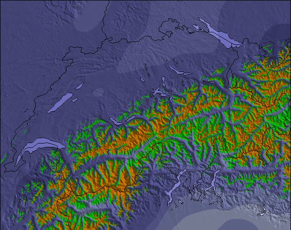
De bovenstaande tabel toont de weersverwachting voor Zermatt op een specifieke hoogte van 2720 m. Onze uiterst precieze weermodellen berekenen sneeuwverwachtingen voor de top, midden en dalstations van Zermatt. Voor weersverwachtingen op andere hoogtes, gebruik de tabbladen boven de tabel. Voor meer weer overzicht, zie de weerkaart van Switzerland.
Klik hier voor meer informatie over sneeuwhoogten en hoe we onze temperaturen berekenen.
Recensies van bezoekers van Zermatt
Algemeen 4.1 Gebaseerd op 92 Stem(men) en 72 beoordelingen
C'est tellement nul de devoir skier pendant quatre jours dans un petit domaine limité alors qu'il y a en fait un immense domaine. On aurait bien pu ouvrir, entre autres, les descentes de Riffelberg à Furi et de Riffelberg à Riffelalp. Les dameuses étaient finalement beaucoup en route et en train de préparer les pistes.
Simplement très mal coordonnées, ou alors on ne voulait pas vraiment ouvrir, mais économiser sur les skieurs....
Alors que les Autrichiens ouvrent toutes leurs remontées tous les matins, qu'il neige, qu'il y ait de la tempête ou du brouillard, les Zermattois ouvrent d'abord une petite partie de leurs remontées. Si l'on a de la chance, un ou deux viennent s'ajouter l'après-midi, si l'on n'a pas de chance, il n'y en a plus du tout.
C'est ce qui s'est passé pour nous pendant les quatre jours que nous avons passés là-bas, du 9 au 12 décembre 2012.
Chez nous, du côté de Zermatt, seules 15 remontées mécaniques sur 54 étaient ouvertes pendant les quatre jours.
Même s'il y avait du vent au col vers l'Italie, on aurait pu ouvrir plus de remontées et de descentes du côté de Zermatt, à l'abri du vent, pour ne pas énerver les clients.
Et puis le prix à débourser pour 4 jours : 316 € pour 15 remontées ouvertes à Zermatt.
En comparaison, pour la même période du 08 au 12 décembre : 189 € pour 31 remontées ouvertes à Ischgl.
137 € de différence !
Jusqu'à présent, j'ai skié à plusieurs reprises dans le Kaunertal, Ischgl, Kappl, Galtür, Ötztal, Zillertal, Kitzbühel, Warth-Schröcken, Damüls, Lech et Oberstdorf.
Partout, ils ouvrent d'abord toutes les remontées mécaniques le matin. S'il y a beaucoup de vent, il arrive que l'une ou l'autre cabine soit brièvement arrêtée jusqu'à ce que la bourrasque se calme.
Mais Zermatt est très différent - on n'ouvre que quelques remontées le matin et on attend de voir si les remontées sont pleines.
Ce n'est pas possible pour une station aussi réputée !
Ce n'est que du vent !
De plus, s'ils étaient honnêtes, ils avoueraient que l'offre de descentes va du bleu au rouge clair - il n'y a pas un seul défi pour les bons skieurs.
Comme les Zermattois sont si snobs, ils ont aussi une gestion des plaintes nulle. Je me suis plaint deux fois auprès du CEO et de la directrice du marketing, mais je n'ai reçu aucune réponse.
Tant pis pour Zermatt - les riches y sont plus importants que le reste du peuple !
Algemeen: 4.1 Gebaseerd op 92 Stem(men) en 72 beoordelingen
Sneeuwzekerheid
4.6
Piste Vercheidenheid
4.7
Off-Piste
4.1
Landschap
4.9
Na het Skiën
4.3
Serge van France schrijft:
C'est tellement nul de devoir skier pendant quatre jours dans un petit domaine limité alors qu'il y a en fait un immense domaine. On aurait bien pu ouvrir, entre autres, les descentes de Riffelberg à Furi et de Riffelberg à Riffelalp. Les dameuses étaient finalement beaucoup en route et en train de préparer les pistes.
Simplement très mal coordonnées, ou alors on ne voulait pas vraiment ouvrir, mais économiser sur les skieurs....
Alors que les Autrichiens ouvrent toutes leurs remontées tous les matins, qu'il neige, qu'il y ait de la tempête ou du brouillard, les Zermattois ouvrent d'abord une petite partie de leurs remontées. Si l'on a de la chance, un ou deux viennent s'ajouter l'après-midi, si l'on n'a pas de chance, il n'y en a plus du tout.
C'est ce qui s'est passé pour nous pendant les quatre jours que nous avons passés là-bas, du 9 au 12 décembre 2012.
Chez nous, du côté de Zermatt, seules 15 remontées mécaniques sur 54 étaient ouvertes pendant les quatre jours.
Même s'il y avait du vent au col vers l'Italie, on aurait pu ouvrir plus de remontées et de descentes du côté de Zermatt, à l'abri du vent, pour ne pas énerver les clients.
Et puis le prix à débourser pour 4 jours : 316 € pour 15 remontées ouvertes à Zermatt.
En comparaison, pour la même période du 08 au 12 décembre : 189 € pour 31 remontées ouvertes à Ischgl.
137 € de différence !
Jusqu'à présent, j'ai skié à plusieurs reprises dans le Kaunertal, Ischgl, Kappl, Galtür, Ötztal, Zillertal, Kitzbühel, Warth-Schröcken, Damüls, Lech et Oberstdorf.
Partout, ils ouvrent d'abord toutes les remontées mécaniques le matin. S'il y a beaucoup de vent, il arrive que l'une ou l'autre cabine soit brièvement arrêtée jusqu'à ce que la bourrasque se calme.
Mais Zermatt est très différent - on n'ouvre que quelques remontées le matin et on attend de voir si les remontées sont pleines.
Ce n'est pas possible pour une station aussi réputée !
Ce n'est que du vent !
De plus, s'ils étaient honnêtes, ils avoueraient que l'offre de descentes va du bleu au rouge clair - il n'y a pas un seul défi pour les bons skieurs.
Comme les Zermattois sont si snobs, ils ont aussi une gestion des plaintes nulle. Je me suis plaint deux fois auprès du CEO et de la directrice du marketing, mais je n'ai reçu aucune réponse.
Tant pis pour Zermatt - les riches y sont plus importants que le reste du peuple !
Gratis Snow-Forecast.com weer-widget voor op je website
De skiweer-widget voor Zermatt is beschikbaar om gratis op te nemen op externe websites. De widget levert een dagelijkse samenvatting van onze sneeuwverwachtingen voor Zermatt en de huidige weersomstandigheden daar. Ga naar de configuratiepagina en volg de drie eenvoudige stappen om de aangepaste html-code te kopiëren en in uw site te plakken. U kunt de hoogte van de sneeuwvoorspelling kiezen (top, midden van de berg of dalstation) en metrische of imperiale eenheden voor de sneeuwverwachting, aangepast op uw eigen website…. Klik hier om de code te krijgen.


 Nearest