Laatste 6 dagenScroll naar links voor de laatste 6 dagenNu
Next 3 days weather summary:
Matige regen (totaal 10.0mm), zwaarst op zondagmiddag. Warm (max 23°C op dinsdagmiddag, min 7°C op zondagavond). Wind zal licht zijn over het algemeen.
Dagen 4-6 Zermatt Weerssamenvatting
Zware regen (totaal 22.0mm), zwaarst tijdens vrijdagavond. Warm (max 25°C op donderdagmiddag, min 14°C op woensdagavond). Wind zal licht zijn over het algemeen.
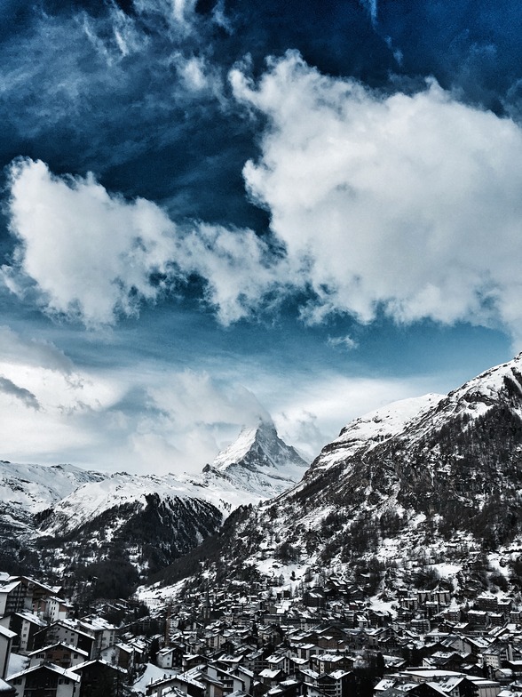
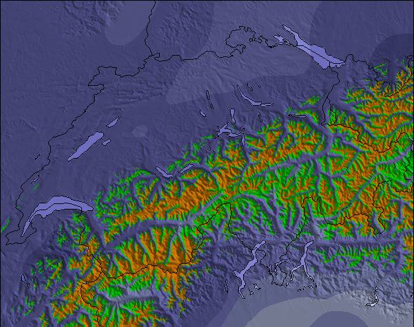
De bovenstaande tabel toont de weersverwachting voor Zermatt op een specifieke hoogte van 1619 m. Onze uiterst precieze weermodellen berekenen sneeuwverwachtingen voor de top, midden en dalstations van Zermatt. Voor weersverwachtingen op andere hoogtes, gebruik de tabbladen boven de tabel. Voor meer weer overzicht, zie de weerkaart van Switzerland.
Klik hier voor meer informatie over sneeuwhoogten en hoe we onze temperaturen berekenen.
Recensies van bezoekers van Zermatt
Algemeen 4.1 Gebaseerd op 92 Stem(men) en 72 beoordelingen
Never again skiing in Zermatt before Christmas!
While the Austrians open all their lifts in the morning, whether it is snowing, storming or foggy, the people of Zermatt first open a small part of their lifts. If you are lucky, one or two are added in the afternoon, if you are unlucky, none at all.
So it was with us in four days we were there from 09 to 12.12.2021.
With us on Zermatt side on all four days only 15 lifts of 54 were open.
Also, if it was windy at the pass to Italy, one could have opened more lifts and departures on Zermatter side in the lee, in order not to annoy the guests (e. g. the slopes from Riffelberg to Furi and from Riffelberg to the Riffelalp, etc.) And then the price you have to shell out for 4 days: 316 € for 15 open lifts in Zermatt.
For comparison in the same period 08 to 12 Dec: 189 € for 31 open lifts in Ischgl.
I was so far in the Kaunertal, Ischgl, Kappl, Galtür, Ötztal, Zillertal, Kitzbühl, Warth-Schröcken, Damüls and Oberstdorf to ski.
Everywhere they open all the lifts in the morning. If it is very windy, one or the other gondola is stopped briefly until the gust has subsided.
But Zermatt is quite different, they open only a few lifts in the morning and then wait to see how full the lifts are.
Such a thing is not possible in a place with such a reputation!
Besides, if they were honest, they would admit that the range of slopes is only from blue to light red, there is not a single challenge for good skiers.
Since the people of Zermatt are so uppity, they also have zero complaint management. I had complained twice to the CEO and the marketing manager, but there was no response at all.
So much for Zermatt, there the rich are more important than the rest of the people!
Algemeen: 4.1 Gebaseerd op 92 Stem(men) en 72 beoordelingen
Sneeuwzekerheid
4.6
Piste Vercheidenheid
4.7
Off-Piste
4.1
Landschap
4.9
Na het Skiën
4.3
AlexSki van United States schrijft:
Never again skiing in Zermatt before Christmas!
While the Austrians open all their lifts in the morning, whether it is snowing, storming or foggy, the people of Zermatt first open a small part of their lifts. If you are lucky, one or two are added in the afternoon, if you are unlucky, none at all.
So it was with us in four days we were there from 09 to 12.12.2021.
With us on Zermatt side on all four days only 15 lifts of 54 were open.
Also, if it was windy at the pass to Italy, one could have opened more lifts and departures on Zermatter side in the lee, in order not to annoy the guests (e. g. the slopes from Riffelberg to Furi and from Riffelberg to the Riffelalp, etc.) And then the price you have to shell out for 4 days: 316 € for 15 open lifts in Zermatt.
For comparison in the same period 08 to 12 Dec: 189 € for 31 open lifts in Ischgl.
I was so far in the Kaunertal, Ischgl, Kappl, Galtür, Ötztal, Zillertal, Kitzbühl, Warth-Schröcken, Damüls and Oberstdorf to ski.
Everywhere they open all the lifts in the morning. If it is very windy, one or the other gondola is stopped briefly until the gust has subsided.
But Zermatt is quite different, they open only a few lifts in the morning and then wait to see how full the lifts are.
Such a thing is not possible in a place with such a reputation!
Besides, if they were honest, they would admit that the range of slopes is only from blue to light red, there is not a single challenge for good skiers.
Since the people of Zermatt are so uppity, they also have zero complaint management. I had complained twice to the CEO and the marketing manager, but there was no response at all.
So much for Zermatt, there the rich are more important than the rest of the people!
Gratis Snow-Forecast.com weer-widget voor op je website
De skiweer-widget voor Zermatt is beschikbaar om gratis op te nemen op externe websites. De widget levert een dagelijkse samenvatting van onze sneeuwverwachtingen voor Zermatt en de huidige weersomstandigheden daar. Ga naar de configuratiepagina en volg de drie eenvoudige stappen om de aangepaste html-code te kopiëren en in uw site te plakken. U kunt de hoogte van de sneeuwvoorspelling kiezen (top, midden van de berg of dalstation) en metrische of imperiale eenheden voor de sneeuwverwachting, aangepast op uw eigen website…. Klik hier om de code te krijgen.


 Nearest