

Portillo Storm Snowfall Total Passes 5m / 17 Feet
A snow storm that has now continued for nine days has taken Chilean ski resort Portillo to a snowfall total of 5.2 metres (17 feet) so far, with more snow forecast.

Next 3 days weather summary:Zware regen (totaal 22.0mm), zwaarst tijdens vrijdagavond. Warm (max 26°C op donderdagmiddag, min 15°C op vrijdagavond). Wind zal licht zijn over het algemeen. | Dagen 4-6 Hochjoch-Schruns WeerssamenvattingZware regen (totaal 26.0mm), zwaarst tijdens dinsdagmiddag. Warm (max 24°C op zondagmiddag, min 15°C op dinsdagmiddag). Wind zal licht zijn over het algemeen. | |||||||||||||||||
donderdag 30 | vrijdag 31 | zaterdag 1 | zondag 2 | maandag 3 | dinsdag 4 | |||||||||||||
AM | PM | nacht | AM | PM | nacht | AM | PM | nacht | AM | PM | nacht | AM | PM | nacht | AM | PM | nacht | |
helder | helder | helder | helder | kans onweer | regenbuien | helder | kans onweer | regenbuien | regenbuien | kans onweer | regenbuien | licht bewolkt | lichte regen | regenbuien | licht bewolkt | zware regen | regenbuien | |
km/h | ||||||||||||||||||
Sneeuw kaart |  |  |  |  |  |  | ||||||||||||
— | — | — | — | — | — | — | — | — | — | — | — | — | — | — | — | — | — | |
mm | — | — | — | — | 1 | 13 | — | 1 | 7 | 1 | 1 | 3 | — | 5 | 2 | — | 11 | 3 |
max °C | 23 | 26 | 24 | 25 | 25 | 16 | 21 | 23 | 19 | 22 | 24 | 20 | 23 | 24 | 20 | 21 | 22 | 17 |
min °C | 20 | 25 | 19 | 21 | 23 | 15 | 17 | 22 | 16 | 18 | 22 | 18 | 19 | 17 | 16 | 18 | 15 | 16 |
chill °C | 20 | 25 | 19 | 21 | 23 | 15 | 17 | 22 | 16 | 18 | 22 | 18 | 19 | 17 | 16 | 18 | 15 | 16 |
Vocht. % | 32 | 23 | 39 | 32 | 50 | 85 | 49 | 51 | 67 | 47 | 55 | 59 | 41 | 78 | 68 | 47 | 86 | 65 |
Vriespunt Niveau m | 4450 | 4600 | 4650 | 4600 | 4500 | 4200 | 4350 | 4400 | 4400 | 4450 | 4550 | 4550 | 4500 | 4450 | 4350 | 4300 | 4300 | 4350 |
5:56 | — | — | 5:56 | — | — | 5:58 | — | — | 5:58 | — | — | 6:01 | — | — | 6:01 | — | — | |
— | — | 8:55 | — | — | 8:54 | — | — | 8:52 | — | — | 8:52 | — | — | 8:51 | — | — | 8:49 | |
Word pro en carve uit:
Lawine-informatie: European Avalanche Warning Services (EAWS)
Laatste sneeuwrapporten in de buurt van Hochjoch-Schruns:
| Sneeuwdiepte op de top: | — |
|---|---|
| Sneeuwdiepte beneden: | — |
| Diepte verse sneeuw: | — |
| Laatste sneeuwval: | 16 May 2026 |
0.0 | Bluebird-poederdagen Verse sneeuw, meestal zonnig, lichte wind. |
|---|---|
0.0 | Poederdagen Verse sneeuw, vrij zonnig, wat wind. |
0.0 | Bluebird-dagen Gemiddelde sneeuw, meestal zonnig, lichte wind. |
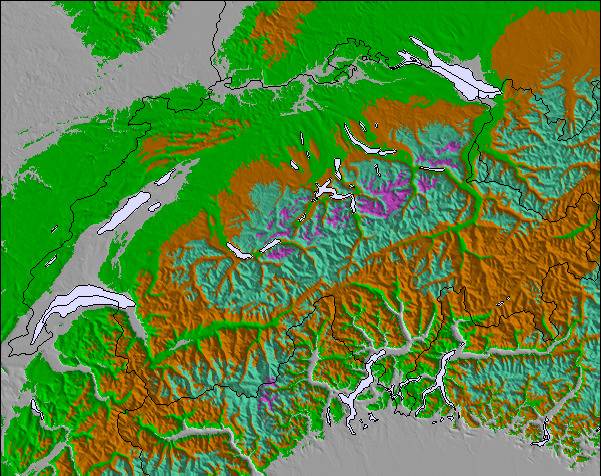
De bovenstaande tabel toont de weersverwachting voor Hochjoch-Schruns op een specifieke hoogte van 1540 m. Onze uiterst precieze weermodellen berekenen sneeuwverwachtingen voor de top, midden en dalstations van Hochjoch-Schruns. Voor weersverwachtingen op andere hoogtes, gebruik de tabbladen boven de tabel. Voor meer weer overzicht, zie de weerkaart van Austria.
Klik hier voor meer informatie over sneeuwhoogten en hoe we onze temperaturen berekenen.
Algemeen 4.5 Gebaseerd op 4 Stem(men) en 2 beoordelingen
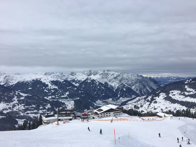
I have been travelling to the Montafon valley, to ski with my family, for the past 10 years. When we started, it was very unusual to hear another English or Irish speaking person there. Amazingly, it's still rare enough! The Montafon valley has a huge variety of ski areas available with first-class facilities. Schruns is a lovely town and although it is not as "manic" as other ski resorts, when it comes to night-life, you can still find enough entertainment and excellent restaurants in the town itself and within a short drive/bus journey. It's Austria's best-kept ski resort secret!
M/ McAllister van Ireland schrijft:
I have been travelling to the Montafon valley, to ski with my family, for the past 10 years. When we started, it was very unusual to hear another English or Irish speaking person there. Amazingly, it's still rare enough!
The Montafon valley has a huge variety of ski areas available with first-class facilities. Schruns is a lovely town and although it is not as "manic" as other ski resorts, when it comes to night-life, you can still find enough entertainment and excellent restaurants in the town itself and within a short drive/bus journey.
It's Austria's best-kept ski resort secret!
Lees 1 meer recensies van Hochjoch-Schruns of stuur je eigen in

 Nearest