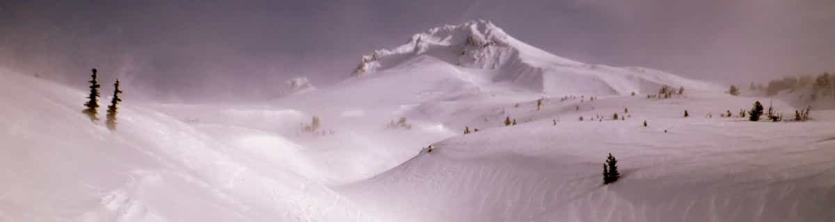


Portillo Storm Snowfall Total Passes 5m / 17 Feet
A snow storm that has now continued for nine days has taken Chilean ski resort Portillo to a snowfall total of 5.2 metres (17 feet) so far, with more snow forecast.

Next 3 days weather summary:Nieuwe sneeuw besprenkeling. Temperaturen onder het vriespunt (max -1°C op zaterdagochtend, min -4°C op donderdagavond). Wind zal licht zijn over het algemeen. | Dagen 4-6 Mount Kenya (Kirinyaga) WeerssamenvattingNieuwe sneeuw besprenkeling. Temperaturen onder het vriespunt (max -2°C op zondagochtend, min -3°C op zondagavond). Wind zal licht zijn over het algemeen. | |||||||||||||||||
donderdag 30 | vrijdag 31 | zaterdag 1 | zondag 2 | maandag 3 | dinsdag 4 | |||||||||||||
AM | PM | nacht | AM | PM | nacht | AM | PM | nacht | AM | PM | nacht | AM | PM | nacht | AM | PM | nacht | |
licht bewolkt | sneeuw buien | licht bewolkt | licht bewolkt | sneeuw buien | sneeuw buien | sneeuw buien | lichte sneeuw | sneeuw buien | sneeuw buien | sneeuw buien | sneeuw buien | sneeuw buien | lichte sneeuw | sneeuw buien | sneeuw buien | sneeuw buien | helder | |
km/h | ||||||||||||||||||
Sneeuw kaart |  |  |  |  |  |  | ||||||||||||
— | — | — | — | — | 1 | — | — | — | 1 | 1 | — | — | 2 | — | — | — | — | |
mm | — | — | — | — | — | — | — | — | — | — | — | — | — | — | — | — | — | — |
max °C | -2 | -3 | -3 | -2 | -2 | -3 | -1 | -2 | -2 | -2 | -2 | -2 | -2 | -3 | -2 | -2 | -3 | -2 |
min °C | -2 | -3 | -4 | -3 | -2 | -3 | -2 | -2 | -2 | -2 | -2 | -3 | -2 | -3 | -3 | -2 | -3 | -2 |
chill °C | -7 | -7 | -8 | -6 | -4 | -6 | -2 | -2 | -4 | -2 | -2 | -6 | -5 | -3 | -3 | -2 | -6 | -7 |
Vocht. % | 42 | 54 | 55 | 44 | 48 | 52 | 42 | 47 | 52 | 47 | 61 | 69 | 66 | 75 | 69 | 57 | 77 | 53 |
Vriespunt Niveau m | 4800 | 4800 | 4550 | 4750 | 4850 | 4700 | 4850 | 4950 | 4800 | 4850 | 4800 | 4800 | 4750 | 4700 | 4600 | 4800 | 4700 | 4750 |
6:33 | — | — | 6:33 | — | — | 6:33 | — | — | 6:33 | — | — | 6:33 | — | — | 6:33 | — | — | |
— | 6:39 | — | — | 6:39 | — | — | 6:39 | — | — | 6:39 | — | — | 6:39 | — | — | 6:39 | — | |
Word pro en carve uit:
Laatste sneeuwrapporten in de buurt van Mount Kenya (Kirinyaga):
| Sneeuwdiepte op de top: | — |
|---|---|
| Sneeuwdiepte beneden: | — |
| Diepte verse sneeuw: | — |
| Laatste sneeuwval: | 5 Apr 2023 |
1.0 | Bluebird-poederdagen Verse sneeuw, meestal zonnig, lichte wind. |
|---|---|
0.1 | Poederdagen Verse sneeuw, vrij zonnig, wat wind. |
4.7 | Bluebird-dagen Gemiddelde sneeuw, meestal zonnig, lichte wind. |
De bovenstaande tabel toont de weersverwachting voor Mount Kenya (Kirinyaga) op een specifieke hoogte van 5199 m. Onze uiterst precieze weermodellen berekenen sneeuwverwachtingen voor de top, midden en dalstations van Mount Kenya (Kirinyaga). Voor weersverwachtingen op andere hoogtes, gebruik de tabbladen boven de tabel. Voor meer weer overzicht, zie de weerkaart van Kenya.
Klik hier voor meer informatie over sneeuwhoogten en hoe we onze temperaturen berekenen.

 Nearest